Saturday, June 29, 2013

Leesburg (Whites Ferry) to Georgetown DC-36 miles


Leesburg (Whites Ferry) to Georgetown (DC)

Our hotel was most interesting as we were staying above a bar in the historic area.  We ate a few doors down at a most fabulous place with lots of wine.  I mean it was the only place with internet for the past three days for us, so how could we possibly use their free internet and not have some wine.   Upon returning to the bar below our rooms we found a Dixieland band playing which was most entertaining.  They were awesome and their ages (mostly 70s and 80s) was encouraging.  Our rooms (ah, let us return to the rooms) were above the bar and reasonably clean and decorated in 70s powder blue.  The bed was comfortable, but all I could think of was a Western where the rooms are above the saloon for one purpose only.  The proprietor was very nice and all in all a good stay and a welcome rest before hitting the trail again. 

Today was supposed to be an easy day of 36 miles into DC, but the microbursts from two nights before left the trail muddy and strewn with trees.  The trees were almost the size of ents from Harry Potter and you couldn’t go around them but instead had to go over them.    Somehow, I tumbled with my bike and put 80 lbs of bike and a chain ring into my kneecap.  Fortunately the knee doesn’t bleed a whole lot, but I do have another set of nice permanent marks on my knee.  This will be great for poolside and cocktail conversation.

We saw more people today than all the days combined as we got closer and closer to DC.  Great Falls was one of the highlights and we saw a taxpayer subsidized canal boat replete with fake actors pulling the tow ropes but sans donkeys as the use of donkeys is probably thought to be demeaning and cruel by the Beltway crowd.  Also, it is the symbol of the Democratic party and some enterprising Republican like me would probably paint a big elephant on the side of the boat thereby creating further commotion.

At the very end of the trail we somehow had to get on Pennsylvania Avenue (yes, THAT Pennsylvania Avenue) and bike into our hotel.  They were a little perplexed as we tried to valet our muddy bikes and unsure whether to charge us for one vehicle (4 wheels) or 2.  In the end they just put the bikes in the luggage room.    They were all impressed with our journey but somehow I was unable to milk this into free drinks. 

We are now leaving DC and this is the last blog of the GAP-C & O Canal.

Part of the B & B amenities

These were not easy to get the bike and paniers over

Mud from the morning, making it hard to pedal

A picture of the gate locks

Great Falls, Great Balls of Fire, we are almost there

The Dam area above Great Falls

An authentic boat

Are we there yet????  Yup

Thursday, June 27, 2013

Harpers Ferry to Leesburg-27 miles

On our rest day, we hiked a bit of the Appalachian Trail to get to Jefferson’s Rock which overlooks the Shenandoah Valley and where you can view the Shenandoah River meeting the Potomac.  It was a very nice spot.  The rock is now “propped” up as it was deemed a hazard sometime in the past.  We left Harpers Ferry going down the big hill that we had so much trouble climbing before.  Over the bridge and down the spiral staircase which was actually harder going down then coming up.  It was a beautiful day and we only had 27 miles so it was an easy day.  We shared the trail with the AT for a few miles. 

I am posting a lot of pics as we got to see the inside of a lockhouse where the keeper was paid $150 per year.  At the end of our day we crossed White’s Ferry to the Virginia side where we stayed in Leesburg.

a little blurb on Harpers Ferry

Leslie at Jefferson Rock
Description of the Riley house

Riley House

Lutheran Church, read below and look at pic

Barren hillside, nothing like today

Stonewall Jackson's HQ

Potomac at Harpers Ferry

Cacotin aqueduct


inside of a blockhouse

looking for dinner

Leslie on the ferry going to Leesburg

Tuesday, June 25, 2013

Williamsport to Harpers Ferry-41 miles


Today we biked about 41 miles to Harpers Ferry.  Our stay in Williamsport was not the greatest as there is ABSOLUTELY NOTHING to do in this town.  OK, other than the ice cream shop and Tony’s where we had a beer.  Our B & B was also not the greatest, so we were glad to be leaving and got a reasonably early start at about 7:40 a.m.   I am quite sure that at Williamsport, that our bed was the WORST I have ever slept in.  So we were glad to get on the road. 

Today the scenery was quite pretty and we saw a lot of nice campgrounds and recreational areas along the canal.  We saw a lot more people than we saw yesterday.  In fact we saw a cyclist sleeping on a picnic table at 10 a.m. over 2 hours after we started.  Do you spell moron with a capital M???  

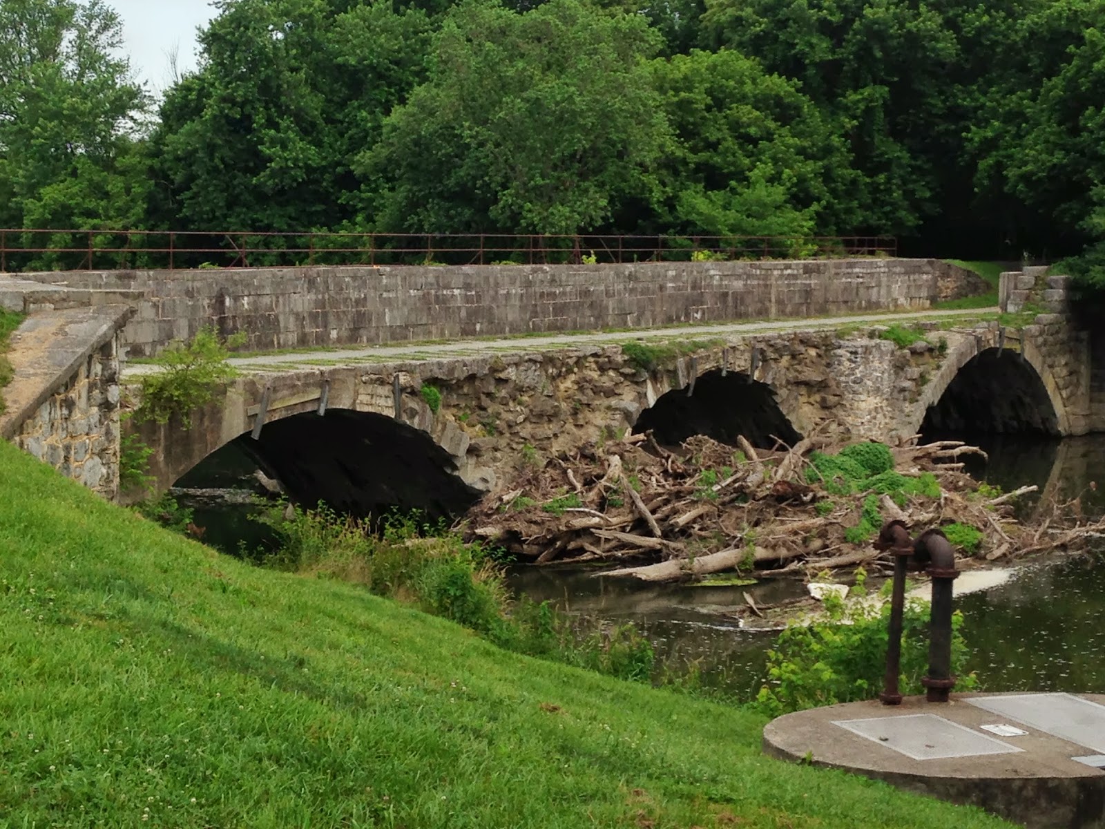
I am posting a shot of one of the eleven aqueducts which is where the canal went OVER the water.  You can see the rightmost canal wall in the background.  These are pretty cool feats of engineering and are in remarkably good shaped for being almost 180 years old.  There are numerous viaducts (150 or too many to count) where streams are channeled under the canal as well.  The Potomac river is notorious for flooding as you are channeling the water from the entire surrounding mountain ranges and combining the water of the upper and lower Potomac, the Cacapon and the Shenandoah (at Harpers Ferry) along with numerous creeks. 

We also had a stretch of a few miles where the canal boats went into the Potomac which was dammed and created what was known as the “big slack”.   The "little slack" was the day before.  The cliff walls are solid rock and the engineers building the canal decided that this would have been too much of a task to carve a canal out of solid rock for 3 miles.  You might recall that dynamite (invented by Alfred Nobel of the Nobel peace prize) was not invented until 1867.  They dammed upstream and downstream to control the water level which not only created a stable area for navigation but also created a steady water supply to feed the canal.  The picture of me on my bike has the downstream dam in the backbround.  Remember the canal was really almost outdated when it was completed as railroads were introduced in the early 1800s and by had supplanted the canal by 1850s.  The canal was built in 1835 and never really paid for itself.  Today, the Federal government would just subsidize it (read passenger rail) and we would still ship goods on the canal under prevailing wage.  I hope you all get the humor in this.

We also biked very close to the Antietam battlefield which was one of the three battles fought in Lee’s Maryland campaign.  Lee was heavily outnumbered by McClellan (2 to 1) and had his army spit (Jackson was at Harpers Ferry) but despite finding a copy of Lee's plans McClellan didn't capitalize on this and the Maryland campaign was a draw.  McClellan didn't concentrate his forces.  Subsequently he was sacked by Lincoln.  This all occurred in 1862.  It was amazing that Lee was able to escape with his army as it is pretty basic military strategy not to fight a superior force with your back against the river.  

In 1863 Lee undertook his second attempt at invading the North and we all know what happened at Gettysburg.  This time he went up againts Meade who had replaced Hooker who had replaced McLellan or something like that.  After his retreat, Lee tried to cross the Potomac (remember he had to get back to Virginai).  At Shepherdstown, we saw the area where Lee had to wait a week after Gettysburg to ford his army as the Potomac was flooded from the storms of July 4th (Gettysberg was July 1, 2, 3 of 1864) that he couldn’t cross and the Union army just dawdled and didn’t take advantage of the situation. 

Finally we arrived at Harpers Ferry where the river is very shallow, wide, rocky and fast moving.  An ideal place for tubing which was in abundance on Sunday when we went through.  To get to Harpers Ferry I had to lug our bikes up a steep spiral staircase where we then crossed a pedestrian bridge to the other side.  Neat, but a lot of work. 

Harpers Ferry was heavily contested in the Civil War changing hands 8 times.  Prior to the battle at Antietam the Union surrendered Harpers Ferry (12,000 plus troops) which was the largest U.S. surrender until Bataan.  Antietam ironically was the bloodiest battle in U.S. history up until that point.  

Lots of history and not many people, but lots of pictures.  Hope you enjoyed today's history lesson.

One of the aqueducts (11) that cross over streams and rivers

In places the canal is dry, places stagnant and places clean

what more can I add.....Lee was apparently a genius or Meade a moron

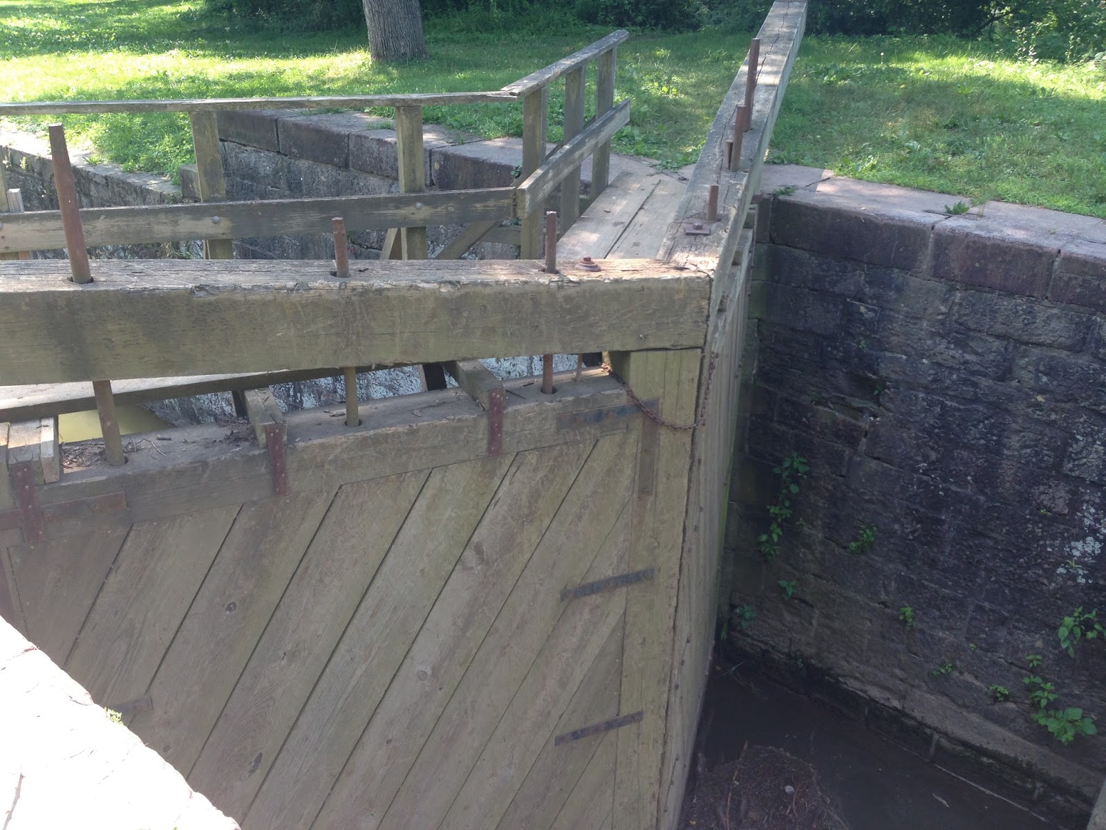
Another lock with lock house in the background where lock keeper stayed

DAMN!!! oops DAM

another lock....ok you get the picture

walking across the Potomac....

YESSSSSS!!!!!!

No one and I mean no one is moving me now.....I was pushing Leslie up the hill

Loved this one.  both sides????  

walking the bike up a portion of the spiral staircase...this was hard.


Little Orleans, MD to Williamsport, MD-41 miles

We had Kirsten shuttle us from the Levi Deal mansion in Meyersdale, PA to the trailhead where she picked us up yesterday at Little Orleans, MD.  Well, actually she slept in the back while I drove.  Since she returned to Pittsburgh I was once again fully loaded with paniers, laptop, backpack, extra bag and all the necessities to maintain Leslie's femininity.  That works out to about 80 lbs with the bike.

It was another hard and fortunately uneventful day.  This is a very sparsely populated area and we didn't see a lot of people.  I think we are one of the few husband/wife teams that do this.

Each canal boat carried 4 mules, 2 that were working and two that were sleeping.  They were fed well and part of the family.  The mules rode resting rode in the front of the boat.  The other two pulled the tow ropes upstream.  Coming downstream was much easier than going upsteam.  The canal has 11 aqueducts where the canal passed OVER the river or creek and over 150 viaducts where they channelled water beneath the canal.  The canal has 75 locks as the elevation change from the high to the low is over 600 feet.  So the mules pulled the boats upstream to Cumberland from D.C. or points downstream and then filled with grain or coal they floated full downstream to the Eastern markets.

We saw many sites and it is a marvel of engineering.  I didn't have any internet connection so I am retyping my notes from memory from 3 days ago.

Here are some of the pics of the day.

Kilns along the C & O

Cement factory

one of the many pumps.....in use today but I hope you like water with your iodine

another lock......old hat at this point


Friday, June 21, 2013

Cumberland, MD to Little Orleans, MD 44 miles

Today we started on the beginning or end depending on your perspective of the C&O Canal.  Actually it is the END.  This is mile 184.5 from D.C.  The canal was originally conceived by Washington to connect the Chesapeake to the Ohio River in Pittsburgh, which would then connect to the Mississippi. Three sections were envisioned to do this with the 1st being the section to Cumberland which is at the base of Mount Savage.  See yesterday's blog or google to understand this   The only completed section was the Eastern Section as it was later determined (duh) that they could not cross the Allegheny mountains.  The canal was begun in 1828 and it reached Cumberland in 1850, but by then the railroad was already there.  One of the key problems of the canal builders was to keep the Germans and Irish immigrant workers from killing one another as they didn't seem to like one another.  A small rebellion also occurred when they cut their daily whiskey ration.  Even back then we had these damn corporate efficiency guys  What the hell were they thinking anyways............

The canal parallels the Potomac River and we saw this as we biked today.  There are 75 locks between Cumberland and D.C. to allow for the boat traffic.  It was really neat today to see this.  What surprised us the most is the degree of wilderness that we travelled through.  Today, this is a VERY remote area and not anything like you would imagine.  Just think "DELIVERANCE" and you have it.  So as they say "a good friend will help you move but a great friend will help you move a body".  This is definitely the place if you need to move a body.

One of the highlights or scary points (they should definitely make a movie here) is the Paw Paw tunnel which is 3100 ft. through the mountain.  We had a narrow, dark, watery lane that was 5 ft. wide in total darkness next to the canal.  Slip and oops, you are done.  Of course there was a railing, I'm just being overly dramatic.  But it was very scary and Leslie and I walked through the tunnel in darkness as we had left the flashlight back at the hotel.  Thats why we brought the flashlight and of course this was my wife's fault as I am the hunter and she is the gatherer.  This WAS NOT FUN.  Eventually we made it through without anything getting us other than our imaginations.  The tunnel was originally estimated to cost $33k or so and in true government fashion it cost over $660k.  Even then cost estimates seem to be off.

Enjoy the pics as it was a long day today.  I am very proud of Leslie as this was a very long and hard ride for anyone, much less in someone with her condition.  Rock on Leslie, as I am ready to turn back.  Just kidding as we are now only 140 miles from D.C. and tomorrow will be less than 100.

The start of the C&O with Cumberland as the backdrop


One of the 'lock houses" where the lock ness monster, gotcha, stayed.....e.g. the guy who attended the lock

Entering the Paw Paw.  This looks easy.....ooops
The Potomac
Confederacy is still alive in Western Maryland
Part of the lock

typical trail....a little rough, but navigable
Little Orleans....must be the late Friday or Saturday nights
Is this Harry Potter, 1/3 lock


$$$$ at Bills  I calculated about a $4,000 ceiling and a $3,000 bar
The swing arms for the locks